In February 2017, Lazio Connect becomes one of the Italian Coperncius Relay (link http://copernicus.eu/sites/default/files/documents/News/NetworkOfCopernicusRelays_ListOfMembers_04Aug2017.pdf ) with the aim of spreading content, services and capabilities offered by the European Copernicus Satellite Program that represents the cornerstone of the European Union’s efforts to monitor Earth and its ecosystems through advanced satellite remote sensing systems. The Copernicus program provides citizens, public authorities, scientists and businesses with a huge amount of information on our planet, in a complete, open and free way.
Copernicus
With the launch in 2014 of the first satellite, Sentinel-1A, the Union has inaugurated the constellation of just over a dozen satellites over the next ten years. Copernicus makes it easier to understand how Earth is an integrated system. European citizens, politicians and administrators, researchers, company and private users, as well as the global scientific community can benefit in many ways from the information provided by Copernicus services.

SENTINEL-1
Launch date:
1A: Launched; 1B: Launched
Payload:
All-weather radar
Revisit time:
1-3 days
Applications:
Monitoring sea ice and the Arctic, land surface motion risk, disaster response

SENTINEL-2
Launch date:
2A: Launched; 1B: Launched
Payload:
Optical sensors with 13 bands
Revisit time:
2-5 days
Applications:
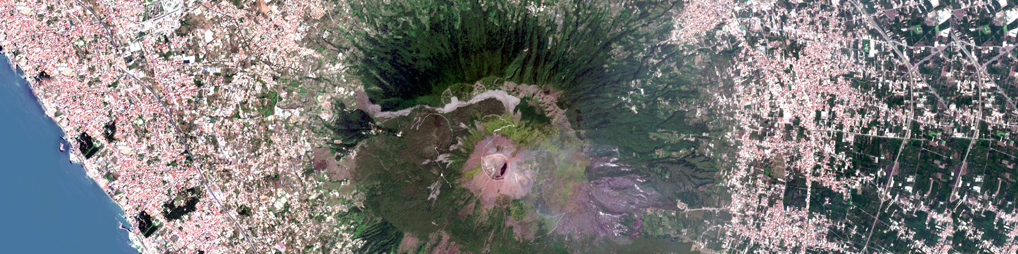
Monitoring land-use changes, agriculture and ecosystems, volcanoes and landslides

SENTINEL-3
Launch date:
3A: Launched; 3B: 2017
Payload:
Sea/land temperature radiometer, sea/land colour instrument
Revisit time:
1-2 days
Applications:
Sea surface and land-ice topography, sea and land surface temperature and colours

SENTINEL-4
Launch date:
Near of this decade
Payload:
Ultraviolet/visible/near-infrade spectrometer
Revisit time:
Geostationary. Hourly coverage of Europe/North Africa
Applications:
Monitoring of air pollution, stratospheric ozone, solar radiation

SENTINEL-5
Launch date:
Near of this decade
Payload:
Ultraviolet/visible/near-infraded/shortwave spectrometer
Revisit time:
17 days
Applications:
Monitoring of air pollution, stratospheric ozone, solar radiation

SENTINEL-6
Launch date:
Mission still under discussion
Payload:
Radar altimeter
Revisit time:
Under discussion
Applications:
Misure global sea-surface height for oceanography and climate studies
These are a few examples of the added value of Copernicus in our daily life:
AGRICULTURE Regular assessment of crop areas; crop development monitoring at regional and global scales; food security assessment; harvest estimation; support to sustainable agricultural practices (e.g. estimated irrigation needs); Copernicus enables an improved understanding of the Earth as an integrated system. European citizens, ranging from policy makers, researchers, commercial to private users, as well as the global scientifi c community can benefi t in many ways from the information provided by the different Copernicus services;
CIVIL PROTECTION AND HUMANITARIAN AID Through the Emergency Response Coordination Centre: coordinated forecast and response to major disasters and humanitarian crises, accurate geographic information for population rescue, logistics, water supply infrastructures, demography, health facilities and environment for those areas aff ected by natural hazards or man-made disasters ;
CLIMATE CHANGE Solid scientific evidence for the geophysical variables addressing climate change, climate indicators (e.g. temperature increase, sea level rise, ice sheet melting, warming of the oceans), climate indices (e.g. based on records of temperature, precipitation, drought events) ;
DEVELOPMENT AND COOPERATION Applications to monitor agriculture and food security, deforestation and desertification, or biodiversity in developing countries in collaboration with partner countries and international organisations (such as the African Union, United Nations institutions);
ENERGY Support to the selection and management of renewable energy production sites through the provision of information on features including water reservoirs, precipitation and snow stored during winter, monitoring of critical assets like nuclear plants, or protection of vital infrastructure like power plants or pipelines; assessment of the effi cient use of energy for industrial plants and buildings;
ENVIRONMENT Monitoring of atmospheric composition, of snow and ice, and of biodiversity, assessment of water cycle parameters like soil moisture or water bodies, monitoring of forests and coastal zones, regular monitoring of soil and assessment of sealed surfaces, forest damage assessment and desertifi cation monitoring (see pages 18-19); monitoring of the oceans and European seas, of the marine and coastal environment, and of marine water quality; observations like ocean color and sea level;
INSURANCE Applications in support of risk modelling, hazard and damage assessment and claims management;
HEALTH European air quality monitoring and global atmospheric composition, mapping of possible outbreaks of epidemics or diseases, preparedness planning for public health emergencies;
BLUE ECONOMY Monitoring the marine environment to enhance marine knowledge and thus support the sustainable development of the marine economy in various sectors such as off shore oil and gas or coastal and maritime tourism;
TOURISM Monitoring of coastal zones, provision of critical indicators and indices for assessment and planning of seasonal tourism activities, such as snow cover, European bathing waters quality, contribution to the protection of natural and cultural heritage;
TRANSPORT AIR, LAND, WATER Monitoring of shipping routes or oil spill monitoring, control of maritime traffi c for safety and surveillance purposes; aviation safety and support to air traffic when extreme situations occur; geo-hazard and environmental risk assessment in critical areas for land transport
SECURITY Support to external actions of the European Union, including peacekeeping operations, monitoring of European land and maritime borders and maritime surveillance at large, in support of a broad spectrum of communities;
URBAN AND REGIONAL PLANNING At regional or city level, land use and land use change monitoring, detailed high resolution maps of EU main cities in support of urban planning to assure sustainable and balanced development .


ACCESS TO COPERNICUS DATA
WHAT IS IT?
URL
USER TARGETS
The PEPS platform aims to provide free and easy access to Sentinel data and to provide processing, training, user acquisition, dissemination and communication capabilities.
Scientific communities and public policy players
The main mission of Theia is to: build a national infrastructure of services and data that can deliver value-added space data on land and provide services tailored to the users needs ; sharing experience and scientific knowledge on the relevant methodologies for spatial data elaboration for thematic issues in the territory.
Scientific communities and public policy actors
The Sentinel Data Hub, the so-called Hellenic National Sentinel Data Hub, or the Greek mirror site, delivers S-1, S-2, S3 and S-5P data throughout the Southeastern Europe (or The Peninsula of the Balkans, next to Italy, France and the Iberian peninsula), as well as the Middle East and North Africa.
Institutions, scientists and researchers, public authorities, space industry players
Catapult Provides satellite access to Earth Observation and related data, as well as tools that can be used to extract information from this data and effectively collaborate with Catapult and other space-based programs.
Institutions, scientists and researchers, public authorities, spacel players, commercial service providers
Thematic exploitation platforms (TEPs: polar / urban / coastal / forestry / hydrologic) are innovative virtual platforms that allow you to derive information from Earth observation data (EO). The main idea of TEP is to provide the users with the indicators rather than the raw data.
All types of users (especially scientists and researchers)
CloudEO is a unique geographic collaboration platform for anyone who creates, interprets, and uses geo data. CloudEO offers a number of geodetic products as well as software and GIS applications from various vendors.
Geo users and developers, geo data providers and geo services, applications and tools
The EODC‘s mission is to collaborate with its scientific, public and private science partners to promote the use of Earth observation data for global water monitoring.
Regional authorities and private users
Sinergise is a GIS company that builds large turnkey information systems mainly in the fields of agriculture and real estate management. They have developed and now provide GEOPEDIA, a web-based application for searching, viewing, and editing a large set of value-added geographic data sets available to many different clients.
National and regional authorities and private users
CS-SI has developed GeoStorm, a geospatial platform for storing, processing and transmitting all kinds of geo-information.
Regional authorities and private users
Amazon services Sentinel-2 data is available to anyone through Amazon S3, both on the Internet and within AWS. All Sentinel-2 scenes are made available, often within a few hours of production.
Developers, private / public users
Google Earth Engine is a computing platform that allows users to perform geospatial analysis of Google’s infrastructure. The Earth engine includes a growing collection of pre-processed Sentinel-1 data using the Sentinel 1 Toolbox. Other data from other sensors are also available.
Developers, private / public users